City of Saskatoon Neighbourhood Traffic Review
Montgomery Place – Meeting 2
8 December 2015
About 80 Montgomery Place residents attended the Traffic Meeting on December 8 in the St. Dominic School gym. The City of Saskatoon Traffic Division staff, following up on the comments they received when they met with Montgomery Place folks in June, 2015, presented 28 recommendations for controlling and calming traffic on Montgomery streets and alleys.
Presentations were given by Jay Magus, Transportation Manager, and Justine Nyen, Traffic Safety Engineer who are “working with your neighbours to come up with the best plan for Montgomery Place.”
Review of City of Saskatoon Traffic Initiatives – Jay Magus
-
North Commuter Parkway and Traffic Bridge
This is a City-led construction project that will be completed by the fall of 2018. The project will link Marquis Drive to McOrmond Drive, and create a new downtown traffic bridge.
-
Saskatoon Freeway
This is a province-led planning study to connect Highway 11 south of the City to Highway 7 south of the City.
-
West Connector Road
This is a partnership with the City of Saskatoon, the RM of Corman Park and the Province of Saskatchewan to connect Highway 16 West to Circle Drive South.
-
Active Transportation Master Plan
This is a City-led planning study of a city-wide cyclist network. A draft plan will be presented to Council in the spring of 2016.
-
11th Street Corridor Study
This is a City-led planning study with the next meeting anticipated in April 2016.
-
Railway Crossings
A Steering Committee is investigating six City rail crossings, including the 11th Street and Dundonald crossings.
Review of June 2015 Montgomery Place Traffic Meeting – Justine Nyen
Montgomery Place residents are concerned about many things including speeding and pedestrian safety, intersection safety, parking, shortcutting, and potholes. Traffic data collectors were placed around Montgomery Place from June to November 2015 to gather statistical data. Eight intersection and pedestrian counters were set up. Nine 7-day, 24-hour traffic counts to register speed and traffic volume were set up. SGI collision history data was studied. Field visits were made. City Transportation officials analysed the data and resident feedback and concluded:
-
Speeding and Traffic Volumes
People drive fastest on the east-west streets. There are also issues on Cassino, Dundonald, Rockingham, Crescent Boulevard, back lanes and the 11th Street Bypass. Montgomery Place people have a skewed perception of speed in their community, City officials contend. Generally the Transportation staff claim, people in Montgomery Place average 47 kph – under the posted speed of 50 kph. (Many Montgomery Place people see that as 7 km over the preferred speed of 40 kph. Perhaps walking on the road and being passed by a car travelling at 50 kph would give City staff a different opinion of safe speeds.)
-
Pedestrian Safety
Yes, we have no sidewalks, and yes, there are children around in school zones, parks and walking on roads throughout the neighbourhood. Dundonald Avenue should have a pedestrian-bike lane or path.
-
Intersection Safety
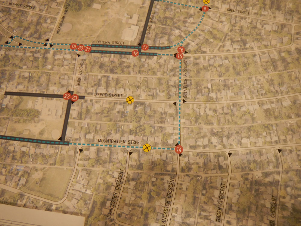
After study, many intersections need Stop or Yield signs. Where Lancaster Boulevard meets the 11th Street Bypass requires further work. The 11th Street corner at Elevator Road and Fairlight Drive requires more work.
-
Parking
Parking narrows the streets even further. Schools zones, intersections and two-sided street parking should be addressed.
-
Other Issues
Trimming trees and bushes, private roadside barriers erected by private homeowners, potholes and poor roads, shortcutting through parks and the 11th Street cul-de-sac – all these issues need attention.
28 Proposals to Calm and Slow Traffic in Montgomery Place
The meeting broke into table groups to review the 28 proposals recommended by City Traffic officials. Most disappointing was the refusal to support a lowering of the speed limit in Montgomery Place to 40 kph. City Transportation officials cannot be convinced that lowering the speed limit would increase road safety. Using the same examples, for instance the Edmonton neighbourhoods that experimented with lowered speed limits, the City argued they were not effective, while the majority of Montgomery residents argued that the drop in average speeds in Edmonton proved the effectiveness of lowered speed limits. The 28 City recommendations do NOT include a call for lowering the speed limit to 40 kph.
City Transportation officials were keen to recommend installing seven pinch points. A pinch point narrows the roadway to one lane, with traffic from one direction having the right-of-way over traffic from the opposite direction that has a Yield sign. Why would we want to narrow our roads further? most residents asked. The recommendation met with little success among Montgomery Place residents in attendance.
City of Saskatoon Transportation staff recommendations include:
-
11th Street at Fairlight Drive and Elevator Road
Move the store billboard to improve visibility. Look at street parking in front of the store that also impedes visibility.
-
11th Street Bypass 130 m west of Crescent Boulevard
Install a 50 kph speed sign.
-
11th Street Bypass and Crescent Boulevard
Move chevron signs to improve visibility.
-
11th Street Bypass 250 m east of Crescent Boulevard
Permanently install a speed display board.
-
11th Street Bypass and Lancaster Boulevard
Install a median island and an additional Stop sign on the south side to enhance the visibility of the stop sign and to ensure drivers are reducing speed to turn left from 11th Street to Lancaster.
-
11th Street Bypass and Lancaster Boulevard
Add this intersection to Saskatoon’s major intersection review. Review westbound and eastbound land configurations.
-
11th Street Bypass from Lancaster Boulevard to Chappell Drive
Enforce the speed limit.
-
Caen Street and Lancaster Boulevard
Paint a standard crosswalk on the north side to improve pedestrian safety.
-
11th Street and Cul-de-sac on east end
Install bollards (posts) to restrict driver access onto Circle Drive and the 11th Street Bypass.
-
Dundonald Avenue South of 11th Street
Install “Not a Through Street” sign or “No Access to Landfill” sign to ensure drivers unfamiliar with the street know that it is no longer the road to the landfill or the railyards. Review overhead signs westbound on 11th Street and southbound on Circle Drive to ensure that the Landfill route is clear.
-
Elevator Road and Caen Street
Install a median island to reduce driver speed.
-
Back Alley south of 11th Street access from Elevator Road
Install a 20 kph speed sign to reduce driver speed.
-
Back Alley south of 11th Street access from Dundonald Avenue
Install a 20 kph speed sign to reduce driver speed.
-
Mountbatten Street and Lancaster Boulevard
To enhance visibility, install “No Parking” signs on the southeast corner 10 m from the intersection.
-
Ortona Street and Lancaster Boulevard
Paint a standard crosswalk on the south side to improve pedestrian safety.
-
Ortona Street and Lancaster Boulevard
Move the bus stop from the centre of the intersection to improve safety.
-
Ortona Street and Currie Avenue
Install “No Stoppiong” signs on the east side of the meridian to enhance visibility and improve pedestrian safety.
-
Ortona Street and Currie Avenue
Paint a zebra (striped) crosswalk on the west side to improve pedestrian safety.
-
Ortona Street and Crerar Drive
Extend the park pathway approximately 20 m west so that the pathway meets the intersection of Ortona and Crerar to improve safety by encouraging pedestrians to cross at the intersection.
-
Ortona Street and Crerar Drive
Paint a standard crosswalk on the east side to improve pedestrian safety.
-
Ortona Street and Crerar Drive
Move the mailbox from the centre median to improve safety.
-
Dieppe Street and Crerar Drive
Install “No Parking” signs on the northwest and southeast corners to indicate that there is no parking 10 m from the intersection to enhance visibility.
-
Dieppe Street and Crerar Drive
Paint zebra (striped) crosswalks on the east and west sides to improve pedestrian safety.
-
Dieppe Street and Haida Avenue
Change the north-south Yield signs to east-west Stop signs.
-
All Intersections Along Bus Routes
Change Yield signs to Stop signs.
-
All Accesses from Dundonald Avenue and 11th Street
Install “Traffic-Calmed Neighbourhood” signs, or signs such as “No Sidewalks – Pedestrians Share Roads,” to raise driver awareness and reduce speeds.
-
Install Pinch Points
Install seven pinch points on Caen, Dieppe and Mountbatten at the eastern entries, at Caen and Crerar, mid-3200 block Dieppe, 3200-block Mountbatten and at Lancaster Boulevard north of the intersection with Caen Street. Pinch points reduce the road to one lane, giving one direction the right-of-way over traffic from the other direction that must obey a Yield sign. Apparently, pinch points reduce speed.
-
Community Programs
Firstly, introduce a Pace Car Program. This would be a neighbourhood-wide initiative where volunteers would pace the traffic driving their own private vehicles. Secondly, purchase a community speed board display to reduce driver speeds. (The Montgomery Place Community Association had already recommended this and is awaiting guidelines currently being drafted by City officials.)
Discussion Following Table Groups
City officials leading the table groups presented brief summaries of the discussion at each table. Comments included:
-
The suggestion that a left turning lane be designated on 11th Street at Crescent Boulevard
-
A right lane be added for cars turning off Lancaster Boulevard onto the 11th Street Bypass
-
More four-way stops rather than two-way
-
Flashing beacons in school zones
-
Creating Stopping zones at the schools, rather than No Stopping zones
-
Pedestrian crosswalks are irrelevant, essentially crossing from ditch to ditch – what is the point?
-
What about speed bumps?
-
Post a 20 kph sign at the alley at Simmonds Park
-
Since the construction of the berm on Burma Road began, vehicles have been shortcutting through the alley behind McNaughton, creating deep ruts.
The biggest question from Montgomery Place residents continued to be – Why can we not lower the speed limit? We have no sidewalks. A car travelling 50 kph feels dangerously threatening when passing walkers and cyclists. The Willows has a 30 kph speed limit. Why can they post a lower speed and we cannot? The City permits reduced speed in school zones. Why would City officials not support a reduced speed in our sidewalk-free community?
City officials maintained that pinch points have been proven effective in reducing speeds. Reduced speed limits have not, they contend. Montgomery Place must petition City Council directly for a reduced speed limit in the community. City Transportation officials will not support the Montgomery Place community.
Comments can be submitted no later than midnight January 8, 2016 at http://shapingsaskatoon.ca/discussions/montgomery-place-neighbourhood-traffic-meeting. The final Montgomery Place Traffic report should be presented to Council in April, 2016.